The Mirador de la Peña sits 645 m up on the rim of the El Golfo cliff. You look straight down into a valley left by an old landslide. Nearly all of El Hierro's volcanic edges are free and within an hour's drive of Valverde.

The El Golfo rim
The viewpoint is a low basalt pavilion with one full-width window onto the valley. César Manrique designed it and it opened in 1989. Below are vineyards and orchards on a volcanic plain, with the Roques de Salmor offshore. It opens 09:00 to 22:30, every day of the year.
There is a restaurant behind that window. The cooking is Canarian and herreño, with fresh fish and local pineapple. Expect €€ for lunch. From Valverde, leave on the airport road and turn onto the upper north road. Guarazoca is a few minutes past Erese.
Mirador de Jinama is about 20 minutes further up, at 1,230 m, the highest stop on the circuit. From the terrace you get the whole El Golfo bay, with vineyards, bananas and pineapples on the valley floor. Nothing is sold here, so bring food and water. There is a car park.

The Camino de Jinama starts at the railing and drops to La Frontera through laurel and fern. It is 8 km with 800 m of descent, so have a plan for getting back up.
A crater under cloud forest
La Llanía is free. It is an easy waymarked circuit through the El Brezal laurel forest. The trees open out onto the grassed-over bowl of the Hoya de Fireba crater. The path then runs on to the Bailadero de Las Brujas. The variants overlap, so you can walk 4 km to 7.5 km.

Start at the La Llanía spring beside the main road near San Andrés, about 15 minutes from Valverde. The turning point is the La Llanía viewpoint over the El Golfo valley. Mist often shuts that view for hours, so treat it as a bonus.
Inside the lava at Guinea
The Ecomuseo de Guinea is the one place on El Hierro where you walk inside a lava flow. The tube is lit and about 90 m long. After it comes the breeding centre for the El Hierro giant lizard, then a row of dry-stone cottages. Each is furnished for a different century, up to the point people abandoned them.
Entry is guided only, every day, with five departures, the first at 09:30 and the last at 15:30. The visit takes about two hours. Adults pay €9.50 and children up to 11 go free. It stands in La Frontera under the Tibataje cliff, with free parking off the road and bus line 4 nearby.
Booking El Julan
Parque Cultural de El Julan in El Pinar is the only way into a stretch of the south-west. From the viewpoint at 850 m you look down a bare slope. Below it the cliff drops to the Mar de las Calmas, and the La Restinga lava field closes the view. Petroglyphs are cut into the open lava up there. The centre's panels cover the Bimbaches, the island's indigenous people.

The centre opens daily from 08:00 to 16:00, with a half-hour break at 14:00, and costs €5 for an adult. The guided route runs every day, by jeep at 09:00 or as a walk out and drive back leaving at 08:00. It is €40 for an adult and includes the centre. Book at least a day ahead, as the jeep takes eight people and the walking route seven. Children under 11 are not admitted, and nor is anyone with reduced mobility. A full-moon version runs on full-moon nights in July and August, booked at least 24 hours ahead.
El Sabinar and the far west
The El Sabinar junipers stand on an open plateau at about 700 m, with the Atlantic behind. The trade wind has corkscrewed their trunks and bent some of them almost flat. The path in leaves from the Ermita de Nuestra Señora de los Reyes and is easy enough for any age. A longer marked route, the PR-EH9, starts at the same chapel and passes the Piedra de los Regidores.

Drive from Valverde towards La Frontera, then climb to La Dehesa, 45 to 60 minutes from the airport beside the capital. The road is narrow, winding and unguarded in places. No bus reaches La Dehesa, so it is a hire car, a taxi or a tour. The Mirador de Bascos on the same road also looks over El Golfo, with the Roques de Salmor behind it.
Playa del Verodal is 150 m of reddish-orange sand on the north-west coast, shut in by cliffs and old lava flows. The currents and surf are strong, so stay out of the water. There is a shower at the entrance and nothing else.

Faro de Orchilla stands at 132 m on the island's westernmost point, on black lava with no vegetation around it. It marked the prime meridian before Greenwich took the title. An unsurfaced track runs from the lighthouse out to the old monument. Go for the sunset or the stars: there is no light pollution and the constellations show all year. The car park is the only facility and no bus comes here. The road in is surfaced but winding. Carry your own water.

Over the Las Playas amphitheatre
Mirador de las Playas is about 20 minutes' drive from Valverde and gives you the biggest drop on the island. The terrace sits at 1,050 m on the lip of an amphitheatre roughly 4 km across. The slopes fall as much as 1,500 m to a bay with almost nothing built on it. Fixed telescopes on the parapet pick out the Parador and the Roque de la Bonanza below. It is often fogged in, and the landmarks usually come back if you give it time. Nothing is sold at the terrace, and San Andrés nearby does traditional food.

Lava pools under the cliff
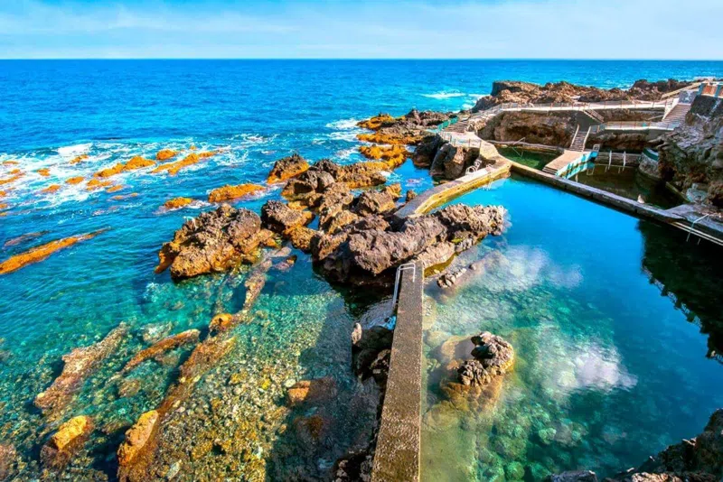
Charco Azul in the El Golfo valley is a deep turquoise pool, half-roofed by overhanging lava. Wooden decks sit beside it and zigzag steps come down the cliff. Old flows shelter it, so the water is usually calm enough to swim. Go at mid tide. There is no lifeguard and the swell outside is strong, so on a big day this is a look. Parking and deck space are limited, so arrive early.

Getting into El Golfo from Valverde means the Los Roquillos tunnel. It has had daytime closures on and off through 2026 for rockfall work above the Camino de La Peña. Check before you set out.
La Maceta is a signposted right turn at La Frontera, the same one that carries on to the Guinea ecomuseum. Several linked pools of different depths sit behind a long dry-stone wall, under the green cliff. Railings and steps lead into the water, and low tide suits it best. There is a large car park, a solarium, toilets, a kids' zone and step-free access. Pick it over Charco Azul if you would rather not scramble. The open sea outside can throw up big breakers.

Fishermen built Pozo de las Calcosas as summer houses at the foot of a black cliff. They have thatched roofs and volcanic stone walls. Two walled pools sit at the bottom, one small and one large. Go at low tide. You park on the clifftop, where there are two restaurants, and walk down. The path is steep in both directions, so skip it if a long flight of steps is a problem. The turn is signposted off the upper north road near El Mocanal, 15 minutes or less from Valverde.

Tacorón on the south coast in El Pinar sits inside the Mar de las Calmas, the calm side of the island. The sand is black and the pools are cut into the lava. Hammock-style sunshades, parking, a solarium and toilets sit on the flat above. Some of it is summer only, so bring water out of season. This is the one to aim for at sunset. Turn right off the road to the island's southern tip just before La Restinga, then walk the short path to the pools.

Before you set out
Book El Julan a day ahead, and Guinea runs on fixed departures, so those two set the shape of your days. Everything else is open ground. No bus reaches La Dehesa or Orchilla, and none of the pools has a lifeguard.
See the El Hierro guide and the El Hierro hotel search.